You do not pass through the village of Bywell on the way to anywhere else, there are no footpaths or bridleways through the village and the road in is a dead end. Although Bywell is only a couple of miles down the river from my home of 12 years, I am a little ashamed to say that until recently I had never visited. I walk in the Tyne Valley almost every day and although many of my walks take me to within sight of the village I have never thought of, or indeed, had reason to make the detour.

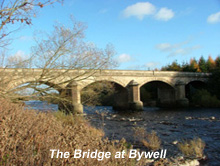
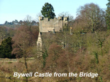
Bywell lies on the north bank of the Tyne, nestling snugly in a loop of the river. Opposite, on the river’s south bank, sits the village of Stocksfield. I walked up to Bywell Bridge, which, is easily reached, from Stocksfield railway station. From the bridge I had a first glimpse of what Bywell has to offer. From the left hand side of the bridge I saw, nestling amongst the trees, the ruins of Bywell

Castle. I reckon that any village boasting it’s own castle has got to be worth further investigation and from the northern end of the bridge a pleasant footpath on the left led me the 300 yards to the village road.
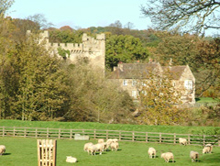
As I entered the village, I got my second view of Bywell Castle, which nowadays comprises three structures: a gatehouse, a section of curtain wall, and Bywell Castle House. The gatehouse was built in the early 15th century by Ralph Neville, second earl of Westmorland but the rest of the castle was never completed. The reason is unclear but it would seem that the Umfravilles, Barons of Prudhoe, didn’t take kindly to another castle so close

to their own and managed to put a block on its completion. Frustratingly, although there are many views of the castle as you walk into the village, trees and walls obscure the building from every vantage point. The castle today is in private hands and you can get no nearer to it than the road.
Walking through the village I began to become affected by the tranquillity and the idyllic setting, a sense of the past lies heavy on this place. Passing a riverside meadow full of quietly grazing and strangely spotless sheep tended by a shepherd lass with bonnet and crook, I was approached by a milkmaid bearing a yoke from which hung two wooden pails of fresh creamy milk that slopped gently as she walked. Little boys whipped tops and chased hens across the street and the hammer blows of the blacksmith shoeing a horse rang in the still air. Ok, I made that last bit up, but such a feeling of having stepped back into a long gone age had the village invoked in me that I wouldn’t have been in the least surprised to have come upon such a scene.
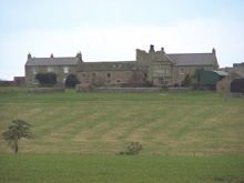
In fact the village was systematically cleared of its inhabitants during the mid to late Nineteenth

Century as the Beaumonts of Bywell Hall created the parkland for their estate. As part of this clearance, the vicar of Bywell St Peters was offered a new vicarage, one that couldn’t be seen from Bywell Hall. The vicar, to his credit refused to budge and so a wall was built to conceal the view of the vicarage from the Hall. This wall became known, aptly, as the ‘Spite Wall’. The eyes of the Beaumonts of the day must have been easily offended as the vicarage of Bywell St Peters is quite the most splendid I think that I have ever seen.
In 1841 Bywell had a population of 130 by 1871 that had been reduced to 20 people mostly inhabiting the Hall and Bywell St Peter Vicarage. If the population today is greater than that I saw no evidence of it and throughout my visit I saw not a soul and had only the sheep for company.

In an area that has many notable and lovely churches Bywell has two of the best, standing less than 100 metres apart. Bywell St Andrew (The white church, once belonging to the Benedictine or black monks), and Bywell St Peter (The black church, once owned by the abbey of Blanchland whose monks wore black). Both have Saxon origins and were originally built to serve two different parishes. Records show that other Northumbrian sites had multiple churches, but only at Bywell do both still survive. Bywell St Andrew is no longer in use and is preserved and maintained by the Churches Conservation Trust.
The village of Bywell was described at the end of the 19th century as “a lovely patch of Arcadia

preserved to the modern world amid all the industrial changes that have transformed some of the fairest scenes in Northumberland into black and hideous wastes”. Although today it would be impossible to describe the surrounding area in those terms, Bywell, preserved in it’s own time warp, has not changed greatly since that time.
Bywell can be visited by taking a very slight detour from the route of
Prudhoe Walk 2: Prudhoe to Ovingham via Stocksfield and Ovington.
History of Bywell
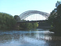 Wylam Railway Bridge to use its official title, although locally it is variously known as Points Bridge, Hagg Bank Bridge, Half Moon Bridge or Bird Cage bridge, was built in 1876, 52 years before construction of the Tyne Bridge was completed. Its single span design however, marks the bridge out as a direct antecedent of both the Tyne and Sydney Harbour bridges. This innovative design was arrived at, by designer W G Laws, through the necessity of having to avoid building piers in the river bed, under which were shallow mine workings.
 another remarkable bridge across the Tyne; William Armstrong’s Swing Bridge at Newcastle, the bridge connected the railway with the Newcastle and Carlisle Railway at West Wylam Junction.
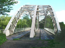 Wylam Railway Bridge is crossed on Wylam walk 2: Wylam Circular via Horsley, Ovingham and Prudhoe and on Prudhoe Walk 3: Prudhoe to Ovingham via Wylam and Horsley. Spectacular views of the bridge can be had from high above the river on both walks.


